
Travel Security
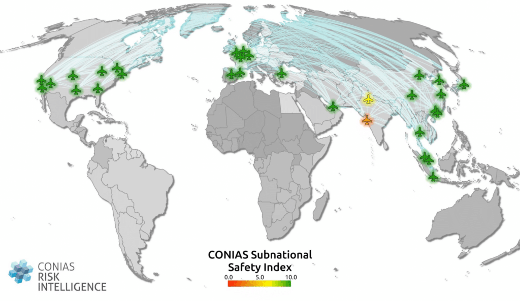
The subnational safety dataset combines monthly and systematically collected conflict data with context data from the recent history of the conflict in the specific area. These include, among other things, the geographical spread, the societal significance and the dynamic of violence. In this way, an individual specific safety score is generated at the provincial, governorate or state level, which is optimized for site monitoring and expat safety as well as travel security.
Make sure that your employees are safe – on Site and on Travels
Our consulting services on travel and site security assessments are characterized by an interdisciplinary, scientifically based and methodically comprehensive approach.
Using our solutions, you can find out with one click,
- whether, to what extent and where employees of your company can travel safely within any country of interest – especially when it comes to first visits and delegation trips,
- how to assess the current security situation at production and supplier locations, as well as important traffic junctions,
- what could be safe zones for employees in case of a crisis and alternative routes that have remained uninterrupted so far.
Predictions without Crystal balls
No one, including us, can predict exactly when an attack or the escalation of peaceful protests will happen at a particular place. However, we can show you which parts of the country are prone to political violence and where the security risk remains low. Our unique, award-winning, and constantly evolving analytical approach combines coverage of all active and historical conflicts in a country.
Our MBI CONIAS Risk Intelligence data indicates,
- where political tensions pose a risk for travel planning and employee safety,
- where political tensions prevail and the outbreak of violence is to be expected
- the regions where the current level of violence renders adjustments to travel plans highly advisable. The regions are placed on a scaled spectrum, which can be understood easily.
- regions, where political violence occurs, yet remains below the threshold of war (visits are possible, but protection and security measures are highly recommended).
KEY DIFFERENTIATORS

Globally consistent and comparable data

Strict quality control

Individual consulting and support

Continuous updating

100 % GDPR compliant
DATA FORMATS
cvs | json
Geo Formats:
Esri Shapefile (.shp) | Esri Geodatabase (.gdb) | MapInfo (.tab) | MapInfo MIF/MID | GeoParquet (.parquet) | GeoPackage (.gpkg) | more on request
UPDATES
Up to twelve updates (by calendar month) can be delivered in one year.
Make sure that your Team is safe – on Site and on Travels
For Travelers
Play it safe at the stopover
Your employees tend to travel frequently and over wide distances – and not just for business?
Then contact us today and optimize your travel management system! We evaluate locations worldwide and without gaps – scientifically and systematically, independently and on the basis of up-to-date, in-house collected data.
For companies
Make safety your location advantage!
You are looking for investors and business partners for your airport and non-aviation business? You want to maximize your revenue potential, attract new customers and increase the volume of passenger at your site?
Then contact us today and receive a free initial assessment – promptly, reliably and confidentially.
Discover More


Heidelberg / Karlsruhe, December 18th, 2025: Global political conflict reached a new high in 2025. …

The first half of 2025 was, at least in the media, dominated by the escalating conflicts between Russia …

It's a paradox: Political risks, including wars and political violence, are consistently ranked among …


Sign up for our MBI CONIAS Risk Intelligence Newsletter to never miss a thing from the world of political risk.

Is it possible to detect political risk early? In this video, we explore this critical question and uncover good news.

Political risk analysis always includes a snapshot of the current situation: What is the current state, is there …