
MBI geocoder
Why Geocoding?
Geocoding is the process to assign geographic latitude and longitude to address information. Reverse geocoding is the process to find the address information for a coordinate, e. g., for tracking.
Geocoded data can be useful for visualization, such as mapping locations where events of interest occur. Geocoding is also often the first step in linking sales, demographics, and economic data for a variety of Geomarketing purposes, such as sales territory and site location.
In today’s business, it’s vital to have a clear understanding of where things are located. What activity is taking place by whom and where. When being able to map your customers addresses and analyze these in relation to the locations of your stores, competitors or logistic hubs, precision, and accuracy are everything. Visualizing this information can result in saved time, costs, and supports planning.
With MBI GEOCODER DESKTOP or MBI GEOCODER API, you get high precision matching of coordinates and addresses. Transform your address database into powerful insights!
MBI Geocoder Desktop
MBI GEOCODER DESKTOP is an application that provides you with high precision matching of coordinates to addresses based on the online HERE global detailed street database.
How does Geocoding work?
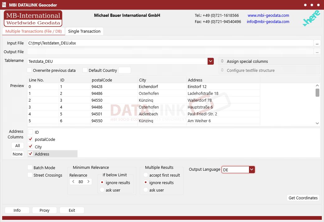
Simply import or drag and drop your address or address list into the application. Once uploaded, a comparison of your addresses with the HERE database takes place. By comparing country name, post code, town, street name and house number of each address the best matching coordinates are found. To process your input data you can use multiple file type’s text, Access or Excel.
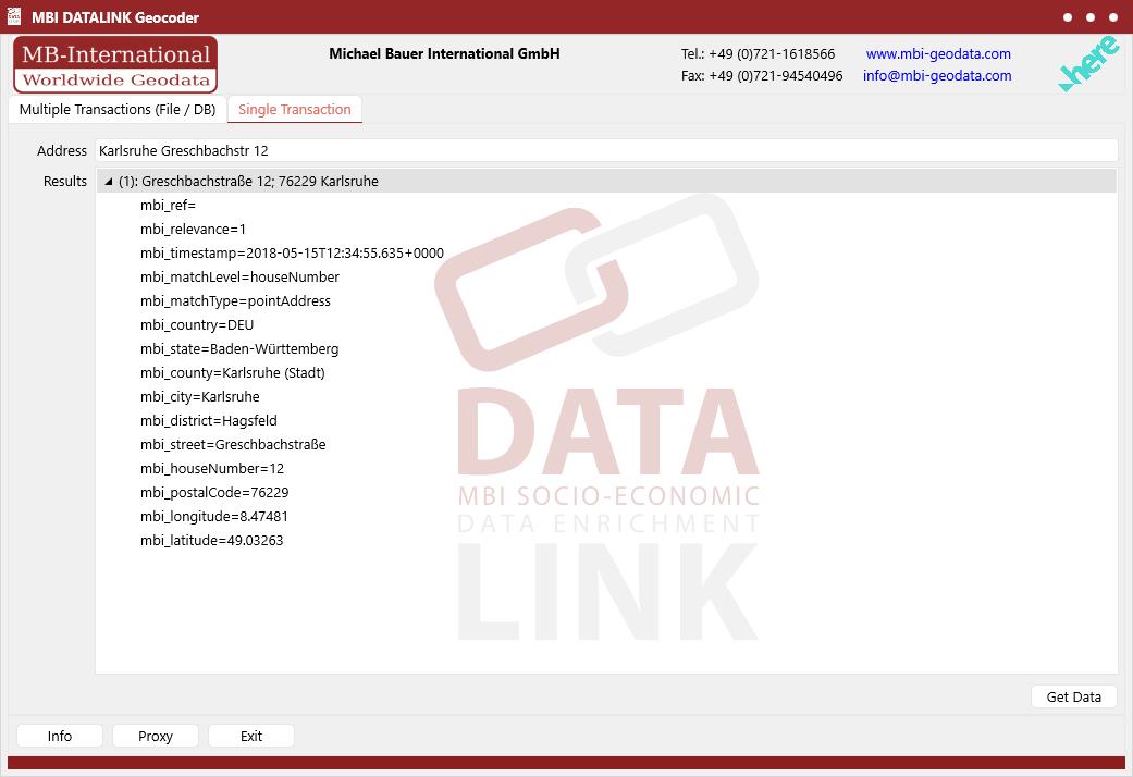
Here two examples of the application showing single and multiple transactions.
Single Transaction
Multiple Transactions
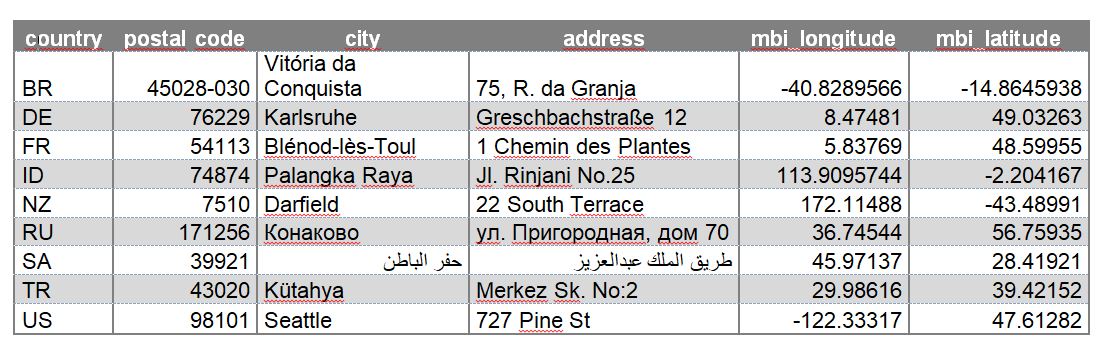
Example of geocoded addresses for different countries
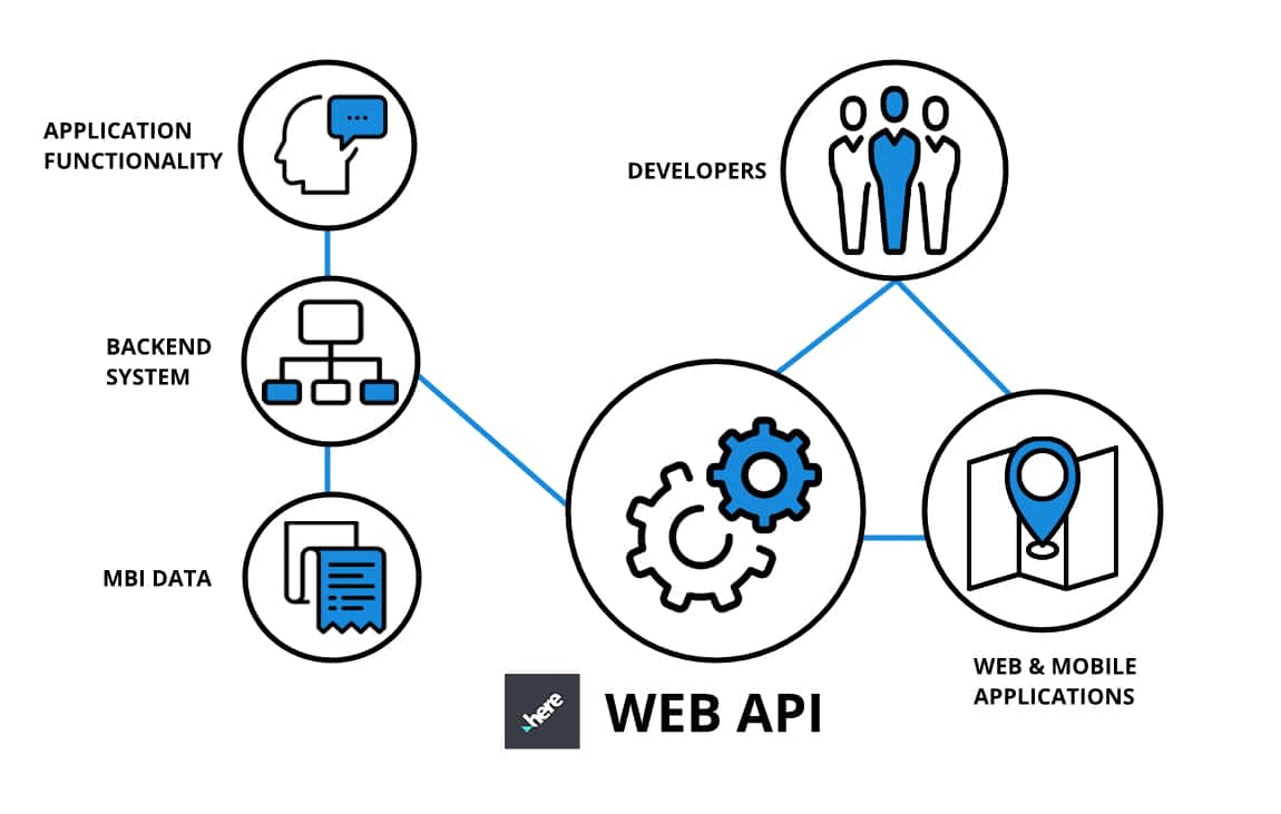
MBI GEOCODER API
API is an “application programming interface”, which is a set of predefined methods of communication between various software components. In basic terms, it acts as a kind of broker, allowing one application to interact with another application. MBI GEOCODER API gives you easy access to the HERE REST API for worldwide and dynamic geocoding. Our RESTful API (RESTful web service) is based on representational state transfer (REST) technology, with responses in JSON format.
Like the MBI GEOCODER DESKTOP, the MBI GEOCODER API accesses the HERE global detailed street database, which delivers precise geocoding results on street level or even on the rooftop of the buildings.
ADVANTAGES OF MBI GEOCODER API
- Web applications avoid the burden of deploying software on each client
- Don’t have to enforce version check in client machine
- Updates are easier
- Makes bug fixes easier
- No administrator rights checking
- Can be accessed from anywhere
- Platform independent
- Support and maintenance are easier
DATA FORMATS
Tab delimited file (TXT) | KML | Access database (MDB) | Excel (xls) | Esri Shapefile (.shp) | Esri Geodatabase (.gdb) | MapInfo (.tab, .tabx) | MapInfo MIF/MID | GeoJSON | GeoParquet (.parquet) | GeoPackage (.gpkg) | more on request
> LEARN MORE
TELL US WHERE YOU ARE HEADING.
WE WILL GLADLY ASSIST YOU IN SELECTING THE DATA NEEDED TO REACH YOUR GOAL.
Didn’t find what you are looking for or have another question? Please do not hesitate to contact us!
Our experts will be happy to advise you individually and without obligation on which data you can use to create added value for your company and realize savings.
Our documentation is available upon request.