CONIAS Risk Data | News | Use Cases
Turning Instability into Insight: MBI CONIAS Political Risk Data Now Available via CARTO
07/29/2025
In an increasingly volatile world, reliable political risk data is no longer a luxury, it’s a necessity. Whether it’s regional instability, social unrest, or shifting governance structures, global businesses must navigate these factors with precision. At MBI, we believe organizations shouldn’t just react to political instability, they should understand it, anticipate it, and plan around it.
In this context, we’re thrilled to share that our MBI CONIAS Political Risk Intelligence is now available in the CARTO Data Observatory, bringing our advanced conflict forecasting and spatial risk data to thousands of users through one of the world’s leading location intelligence platforms – making it easier than ever for analysts, planners, and strategists to access powerful, predictive conflict data directly within their geospatial workflows.
This launch marks another milestone in our long-standing partnership with CARTO, a collaboration that has helped deliver powerful, location-driven insights to customers worldwide. Together, we’re making complex political risk data not only more accessible but more actionable.
What Sets MBI CONIAS Risk Intelligence Apart?
Unlike many conflict datasets that focus on raw event reporting or static classifications, the MBI CONIAS Risk Intelligence dataset is built for clarity, context, and decision-making. Our data doesn’t just capture where conflict occurs, it explains why it occurs, how it develops, and where it’s likely to escalate next.
Core Components of the Data:
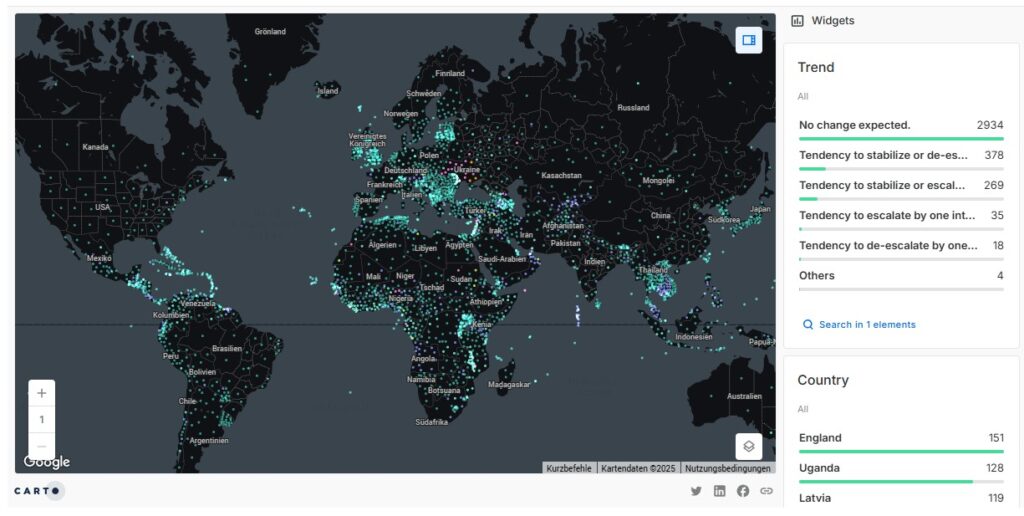
- Conflict Presence: Real-time snapshots of political tensions, including conflict type, frequency, and duration at subnational scale.
- Trend Forecasting: Our predictive risk models forecast political instability over a 12-month horizon with 80%+ accuracy, supporting forward-looking planning and early intervention.
- Conflict Insights: Contextual intelligence on the root causes of unrest, categorized by drivers such as governance issues, economic inequality, natural resource stress, or identity-based divisions.
All data modules are geospatially standardized (e.g. via ISO codes), allowing seamless integration into internal tools, dashboards, and risk models.
Empowering Smarter Decisions Across Industries
With MBI CONIAS now integrated into CARTO’s cloud-native platform, organizations can access, explore, and visualize political risk data without complex ETL processes or data wrangling. This streamlined access is especially vital for industries that need to act fast and stay informed.
Sample Applications:
- Finance & Insurance: Incorporate political volatility into credit ratings, investment screening, and risk-weighted valuation.
- Supply Chain & Logistics: Identify high-risk corridors and proactively reroute logistics operations.
- Expansion Planning & Market Entry: Evaluate regional stability before entering new markets.
- Urban Planning & Development: Prioritize infrastructure projects based on conflict exposure and risk trends.
- Humanitarian Aid & Development: Optimize aid delivery and personnel deployment based on reliable, forward-looking conflict assessments.
By delivering both historical depth and future-facing risk projections, the MBI CONIAS dataset turns geopolitical complexity into actionable clarity, especially when visualized with CARTO’s dynamic geospatial tools.
Geospatial Intelligence Meets Predictive Risk Modeling
By combining spatial precision with temporal forecasting, MBI CONIAS gives users a critical edge. It bridges the gap between geospatial intelligence and political analysis, allowing users to monitor threats in real time, understand historical risk trajectories and plan future operations with confidence.
The integration with CARTO’s platform empowers users to interactively explore risk data through visualizations, dashboards, and AI-powered spatial agents, turning complex datasets into strategic insight in seconds.
Ready to Rethink Your Risk Strategy?
Political landscapes are dynamic. Your data should be too. With MBI CONIAS Political Risk Intelligence, organizations gain access to one of the most advanced political risk datasets on the market, now enriched by CARTO’s visualization and analytics tools.
Let us help you transform global instability into strategic foresight. Explore the data in the CARTO Data Observatory or request a demo to see how MBI CONIAS can elevate your geopolitical risk assessments.
About the authors:

Helen McKenzie
Geospatial Advocate
CARTO

Dr. Nicolas Schwank
Chief Data Scientist Political Risk
Michael Bauer International GmbH